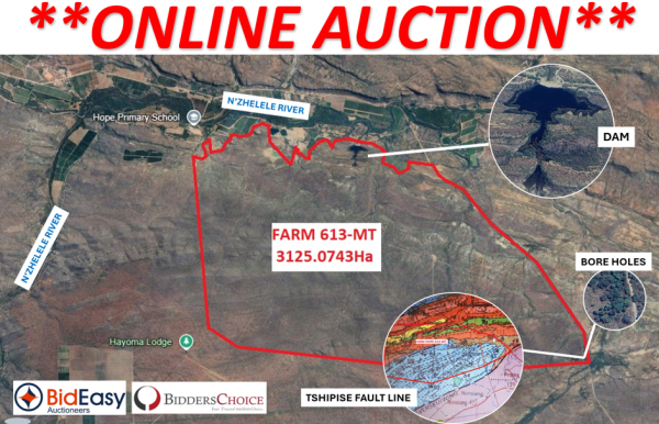


This is a large uncultivated Farm of 3125Ha in the Musina District, Limpopo, on the Tshipise Fault Line with Water Rights of 3 840 000m3 p.a. Irrigation Farming Opportunity of 500Ha in a well-established large scale farming node on the Tshisipe / N’Zhelele Fault Line. There is also a Storage/Irrigation Dam with registered/ surveyed capacity of 269 251m3 per annum on the farm. The dam has a sluice that carries water from the N’Zhelele river (N’Zhelele dam) canal system. The farm is also located in the Soutpansberg Karoo Trough that feeds the N’Zhelele River with rain and run off.
Farming along this fault line and in this basin has resulted in many ultra large-scale irrigation farms that have been sustained successfully over many years.
Uncultivated Land Soil Fertility and Health
Virgin land typically has rich, undisturbed soil with a natural balance of nutrients and organic matter. There is better water retention and microbial activity which supports healthy crop growth.
No history of chemical use means a low risk of contamination, making it ideal for organic farming or regenerative agriculture. Virgin or unused land has a lower entry cost compared to already developed farmland.
This farm has Red Soil. The agricultural potential for red soil can support various agricultural activities.
Strategic Location
Farm Hope is located near Musina and the Beitbridge border post, a key trade route to Zimbabwe and the rest of southern Africa. This makes export of fresh produce or livestock easier and more cost-effective.
The region is also receiving increasing attention from infrastructure and mining projects, which may boost demand for agricultural products.
Climate and Water Access
Musina has a semi-arid climate but with proper planning (e.g. boreholes, water catchment systems, aquifers), certain crops like export grade avocado, macadamia nuts, citrus, grapes, etc, can thrive. Of importance is that this farm has 4 Boreholes with Water Rights on the Tshipise Fault Line, as well as a large capacity Dam.
Investment Opportunity
The growing demand for food in South Africa and across neighboring countries means there's a high market potential.
Investing in new farming operations contributes to food security, which is a priority area for both public and private sector investment, especially in proximity to development corridors (e.g. N1 highway, Musina-Makhado SEZ).
Tshipise Fault Line
Farming on or near a geological fault line — such as the Tshipise Fault Line has benefits. While fault lines are often associated with seismic activity, they can also bring unique advantages to agriculture, depending on the specific local geology, soil, and hydrology. This farm also has large subterranean water trough.
There are 4 Boreholes on the farm with Water Rights as well as Catchment and Potential Recharge Areas of the boreholes as indicated by hydrogeologists.
Soutpansberg Influence
The nearby Soutpansberg mountains contribute recharge to the system via rainfall and runoff infiltrating along fractures.
The geology of the Soutpansberg area includes Precambrian basement rocks and younger sedimentary rocks, creating a complex hydrogeological setting.
Groundwater in the region is heavily used for rural water supply, agriculture, and livestock.
Rainfall and Runoff Dynamics
The Soutpansberg Mountains receive substantial rainfall, among the highest in South Africa. This orographic rainfall, where moist air is lifted over the mountains, results in significant runoff that feeds into the region's rivers, including the Luvuvhu, Mutale, and N’Zhelele.
Dam
There is a large catchment dam on the farm of up to 269000m3 per annum. The dam has dam walls to manage the water flow.
The dam is filled during the rain season with run off the catchment area by way of three natural waterways and are gravity fed from the boreholes and the N’Zhelele canal system.
Boreholes and Water Rights
There are 4 Boreholes on the farm where the farm converges with the Tshipise Fault Line. The boreholes feed the farm by gravitation with water for Irrigation and for the storage Dam.
The borehole pressure has been tested in May 2025 and the results have not fluctuated from the testing concluded in 2019, therefore the borehole pressure is consistent.
UPSIDE: G1 Stone Quarry / Mineral Deposits
The Musina area is geologically favorable for quarrying. The region is underlain by gneisses and other metamorphic rocks, which are suitable for producing high-quality aggregates which are essential for road base and sub-base applications.
Ther are clear indications of Coal Deposits, and a Magnesite deposit has previously been mined on this farm.
There is a granite G1 quarry on the property with rock of exceptional quality. Material was used by SARAL in 2021 to build the N1 Musina ring road. Material was crushed by B&E International.
An off-take agreement for another 500 000 tons of G1 material with B&E International is in place to repair the N1 from Masequa towards the Baobab toll gate. See Agreement, quality report and above ground survey of material. Underground quantity still to be mapped.
The current 5 year permit to mine G1 Stone lapses in September 2025 and an application could be made for a new 5 year period.
Geoland Survey Report available on request.